April 12, 2023 - Flying the Nanticoke and Pokomote Rivers |
||||||
|
Today, the plan was to fly the Nanticoke and Pokomoke Rivers. I've flown parts of them but never their entirety. Today's the day. I began by heading towards the town of Seaford, which is at the head of the Nanticoke. That's Highway 404 below, our normal route to Ocean City. I never realized that it passes so close to the head of the Tuckahoe Creek, which is just visible at center right. |
||||||
![]() |
||||||
| Following Tuckahoe Creek southeast which to the Choptank River. | ||||||
![]() |
||||||
|
Passing the Choptank River, looking southwest.
|
||||||
![]() |
||||||
| Passing a little private grass strip called Slater. | ||||||
![]() |
||||||
| And there is Seaford, Delaware. | ||||||
![]() |
||||||
|
Another look at Seaford with the Nanticoke River running through it. Seaford has a population of 6,928. I was surprised to learn it has the second highest crime rate in Delware -- Wilmington being the highest. |
||||||
![]() |
||||||
|
Highway 13 runs through Seaford North-South. Here, looking north.
|
||||||
![]() |
||||||
| OK, now I'm heading south down the Nanticoke River. | ||||||
![]() |
||||||
|
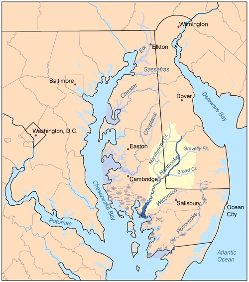
Map of the Eastern Shore rivers with Nanticoke highlighted.
|
||||||
![]() |
||||||
| A little car ferry crosses the river. | ||||||
![]() |
||||||
| Not much civilization south of Seaford near the river. | ||||||
![]() |
||||||
![]() |
||||||
|
The little town of Sharptown and the Sharptown Road Bridge.
|
||||||
![]() |
||||||
| Back to forest. | ||||||
![]() |
||||||
|
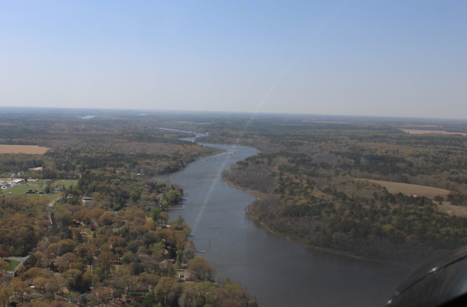
Passing one of the many branches or creeks off the river.
|
||||||
![]() |
||||||
| Approaching the Nanticoke River Bridge which is where Highway 50 crosses over on its way to Ocean City. | ||||||
![]() |
||||||
| Just past the bridge is the little town of Vienna with its big Vienna Generation Center at right. | ||||||
![]() |
||||||
| Now the river opens up and enters marshland. | ||||||
![]() |
||||||
|
More water than land at this point.
|
||||||
![]() |
||||||
| An unusual-looking little pusher tug boat. | ||||||
![]() |
||||||
|
Another tug pushes a single barge down the river to the Chesapeake Bay.
|
||||||
![]() |
||||||
| Close-up of the tug/barge. What's the cargo? Grain? Sawdust? | ||||||
![]() |
||||||
|
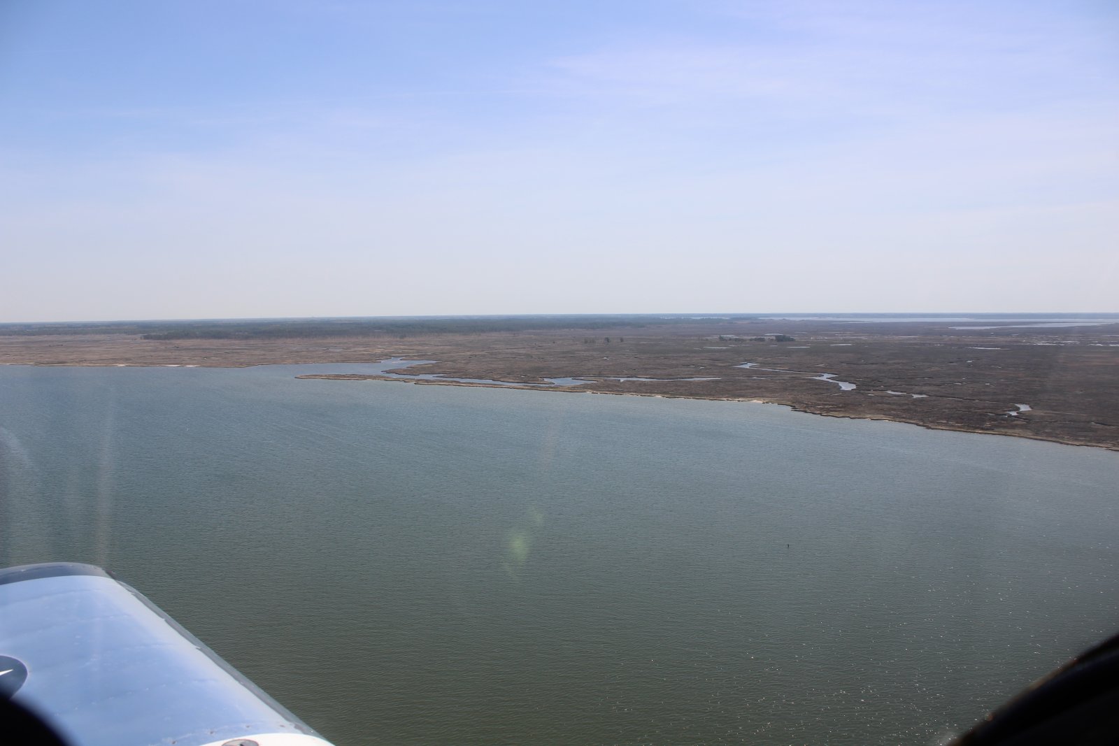
Now entering the Blackwater marsh area.
|
||||||
![]() |
||||||
| Won't be long now until everything turns green. | ||||||
![]() |
||||||
|
Then I'm out into the Chesapeake Bay. Looking down at an interesting sand bar. |
||||||
![]() |
||||||
| Heading south down the Eastern Shore, passing by a little trailer-home community. | ||||||
![]() |
||||||
|
|
||||||
![]() |
||||||
![]() |
||||||
|
|
||||||
![]() |
||||||
![]() |
||||||
| Still heading south. | ||||||
![]() |
||||||
| Pretty sand bars. | ||||||
![]() |
||||||
|
|
||||||
![]() |
||||||
![]() |
||||||
|
|
||||||
![]() |
||||||
| And then I flying by Crisfield Airport. | ||||||
![]() |
||||||
| Looks pretty deserted. It's been years since I landed here. | ||||||
![]() |
||||||
| Unfortunately Crisfield's grass runway is no longer in use. | ||||||
![]() |
||||||
|
The town of Crisfield.
|
||||||
![]() |
||||||
| Main Street, Crisfield. | ||||||
![]() |
||||||
|
Looking west at Smith Island.
|
||||||
![]() |
||||||
| Looking southwest at Tangier Island in the distance. | ||||||
![]() |
||||||
| Rounding Cedar Island preparing. | ||||||
![]() |
||||||
| Still rounding Cedar Island. | ||||||
![]() |
||||||
|
Looking north back at Crisfield.
|
||||||
![]() |
||||||
| Pretty marshy out here. | ||||||
![]() |
||||||
|
A remote house accessible only by boat.
|
||||||
![]() |
||||||
| A house with nice waterview. | ||||||
![]() |
||||||
| This house is going for the elevated view. | ||||||
![]() |
||||||
| And finally, there is is! The entrance to the Pocomoke River. | ||||||
![]() |
||||||
|
OK, here we go.
|
||||||
![]() |
||||||
| Mansion on the Pokomoke River. | ||||||
![]() |
||||||
|
This river twists and turns quite a bit.
|
||||||
![]() |
||||||
| Passing by the Vulcan Materials Company. My guess: sand and gravel. | ||||||
![]() |
||||||
|
On the left emerges the Eastern Shore Forest Products company. Maybe they make telephone poles?
|
||||||
![]() |
||||||
| What are allthose white containers? Bags of sawdust? Wood chips? | ||||||
![]() |
||||||
|
Soon after comes Pokomoke City, Maryland. Population 4,184.
|
||||||
![]() |
||||||
|
Not a good picture, but Highway 13 crosses the Pocomoke River into Pocomoke City.
|
||||||
![]() |
||||||
|
The river straightens out after Pocomoke City.
|
||||||
![]() |
||||||
| Not much civilization on either side. | ||||||
![]() |
||||||
| A solitary house/farm on the riverside. | ||||||
![]() |
||||||
| How they biting? | ||||||
![]() |
||||||
|
The river is still sizeable.
|
||||||
![]() |
||||||
| Some twists and turns. | ||||||
![]() |
||||||
|
Approaching the town of Snow Hill, Maryland, which I've never been to. Never heard of, as a matter of fact.
|
||||||
![]() |
||||||
| A better look at Snow Hill, population 2,103. | ||||||
![]() |
||||||
| Beyond Snow Hill the river turns into a jumble and then just ends. | ||||||
![]() |
||||||
| I'm fairly close to the Ocean, so I just turn east and head for Assateaque Island. | ||||||
![]() |
||||||
|
Flying over the bay about to his Assateaque Island.
|
||||||
![]() |
||||||
| Looking north. | ||||||
![]() |
||||||
|
You can drive vehicles on the sand here. Better have four-wheel drive and deflate your tires!
|
||||||
![]() |
||||||
| Lots of vehicles on the beach this day. | ||||||
![]() |
||||||
| Checking out the beach action. | ||||||
![]() |
||||||
| Lots of campers down there at the Oceanside Walk-in Campground. | ||||||
![]() |
||||||
|
Assateaque Island State Park.
|
||||||
![]() |
||||||
| Ocean City ahead but I've seen it multiple times the last two months so I turn northwest and head for home. | ||||||
![]() |
||||||
|
Passing by a very nice estate on South Point.
|
||||||
![]() |
||||||
| Climbing up high for transit home. Boring! That's Highway 50 down there, heading to Salisbury. | ||||||
![]() |
||||||
|
Passing by Seaford at high altitude. So I have made a big circle today.
|
||||||
![]() |
||||||
| Looking down at the Eastern Shore, about to go feet wet over the Chesapeake Bay. | ||||||
![]() |
||||||
|
Wings over the Chesapeake!
|
||||||
![]() |
||||||